EXPLORE: Earthquakes (BrainPop)
| Site: | Mountain Heights Academy OER |
| Course: | Earth Science Q2 |
| Book: | EXPLORE: Earthquakes (BrainPop) |
| Printed by: | Guest user |
| Date: | Thursday, 24 July 2025, 9:04 PM |
1. Earthquakes
An earthquake is the vibration, sometimes violent, of the earth’s surface that follows a release of energy in the earth’s crust. Earthquakes are created by natural processes related to the shifting of the earth’s crust. The slow movement of the plates causes strain to build in the rock. The crust may first bend and then, when the stress exceeds the strength of the rocks, break and “snap” to a new position. In the process of breaking, vibrations called “seismic waves” are generated. These waves travel outward from the source of the earthquake along the surface and through the earth at varying speeds, depending on the material through which they move.
What can cause an Earthquake?
The shifting of magma within a volcano can also build up stress that may cause an earthquake. The rebound of land when an ice sheet melts away can also produce earthquakes. Extraterrestrial sources of earthquakes are the impact of meteors and comets which occasionally collide with the earth. Humans can produce small “earthquakes” by detonating underground nuclear weapons, as was done in the 1950s and 1960s. But by far, the most common trigger of an earthquake is the motion of the plates of the earth. In fact, plate boundaries are mapped by marking the tens of thousands of earthquakes that occur each year along the earth’s plate boundaries. The location of the quakes tells scientists that the most likely place for a quake is the edge of a moving plate.
Source http://pubs.usgs.gov/gip/earthq1/how.html (public domain)
2. Earthquake Basics
This presentation reviews some important information and vocabulary about earthquakes.
3. How do Earthquakes Happen? (BrainPop)
The following video describes why earthquakes occur, where they happen, the types of seismic waves associated with earthquakes, and how scientists measure seismic waves.
4. Movement of P-waves and S-waves
This video demonstrates the movement of primary and secondary earthquake waves.
5. Wasatch Front Earthquakes
While most earthquakes happen at plate boundaries, not all earthquakes happen there. In fact, the earthquakes that happen in Utah are not the result of the movement at plate boundaries. Earthquakes in Utah occur as a result of the North American plate moving over the Yellowstone Hot Spot. Hot spots are stationary areas where magma in Earth's interior is rising to the surface. Volcanic activity and earthquakes are associated with this slow movement of the plate over the hot spot. The largest and most active of faults associated with this plate movement is the Wasatch Fault, located in northern Utah.
6. Measuring Seismic Waves in Utah

In collaboration with researchers at the Utah Geological Survey, University of Utah, Utah State University, Brigham Young University, San Diego State University, and private industry, the Geologic Hazards Team Intermountain West MegaProject has conducted several high-resolution seismic imaging investigations along the Wasatch front, in order to better characterize earthquake hazards and ground motion in this region. These studies, to date, have been focused in the Salt Lake and Utah Valleys.
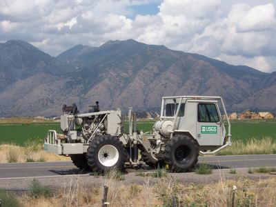
To conduct their study, scientists used shaker trucks to model what happens during an earthquake. Two different types of shaker trucks have been used in the studies. The small ones, called “minivibes”, gently shake the ground and provide information about the ground structure down to about 100 feet (approximately 30m) below the surface. The larger-scale shaker trucks, called “Liquidators”, generate long-period (low-frequency) seismic waves that penetrate deeper into the crustal structure down to 1000 feet (approximately 305m). The shaker trucks can shake the ground either in the horizontal direction to generate P-waves, or in the vertical direction to generate S-waves.
From the echoes that are recorded as the seismic waves bounce back to the surface from the various geologic structures beneath, we can create a subsurface image and estimate how fast seismic waves travel beneath a site. Both the image and the wave speeds are important to more accurately determine how the soils and rock will behave during an earthquake.
Source: http://earthquake.usgs.gov/regional/imw/imw_seis/ (public domain)