EXPLORE: Theory of Plate Tectonics
| Site: | Mountain Heights Academy OER |
| Course: | Earth Science Q2 |
| Book: | EXPLORE: Theory of Plate Tectonics |
| Printed by: | Guest user |
| Date: | Friday, 25 July 2025, 1:32 AM |
Description
.
1. READ: From Continental Drift to Plate Tectonics
It wasn't until almost 30 years after Wegener's death that the scientific community realized his ideas about continental drift were correct. Advances in technology allowed scientists to map and study properties of the ocean floor in greater detail. Such developments would eventually provide scientists with enough evidence to fill in the gaps of Wegener's theory, and explain how the continents moved across the surface of the Earth.
2. READ: Mapping the Seafloor
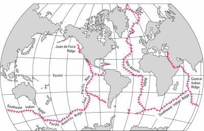
Photo courtesy of USGS. Image is in the public domain.
About two thirds of the Earth's surface lies beneath the oceans. Before the 19th century, the depths of the open ocean were largely a matter of speculation, and most people thought that the ocean floor was relatively flat and featureless. However, as early as the 16th century, a few intrepid navigators, by taking soundings with hand lines, found that the open ocean can differ considerably in depth, showing that the ocean floor was not as flat as generally believed. Oceanic exploration during the next centuries dramatically improved our knowledge of the ocean floor. We now know that most of the geologic processes occurring on land are linked, directly or indirectly, to the dynamics of the ocean floor.
In 1947, seismologists on the U.S. research ship Atlantis found that the sediment layer on the floor of the Atlantic was much thinner than originally thought. Scientists had previously believed that the oceans have existed for at least 4 billion years, so therefore the sediment layer should have been very thick. Why then was there so little accumulation of sedimentary rock and debris on the ocean floor? The answer to this question, which came after further exploration, would prove to be vital to advancing the concept of plate tectonics.
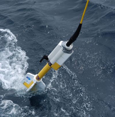
One technological advance that helped scientists study the ocean floor in more detail was the development of echo-sounding methods such as sonar. Sonar works by emitting sound waves to measure distance by recording how long it takes for sound waves sent from a ship to bounce off the ocean floor and return to the ship. This helped scientists measure ocean depth and seafloor topography. Time graphs of the returned signals revealed that the ocean floor was much more rugged than previously thought. Data gathered by oceanographic surveys conducted by many nations led to the discovery that a great mountain range on the ocean floor virtually encircled the Earth.
Called the global mid-ocean ridge, this immense submarine mountain chain -- more than 50,000 kilometers (km) long and, in places, more than 800 km across -- zig-zags between the continents, winding its way around the globe like the seam on a baseball. Rising an average of about 4,500 meters(m) above the sea floor, the mid-ocean ridge overshadows all the mountains in the United States except for Mount McKinley (Denali) in Alaska (6,194 m). Though hidden beneath the ocean surface, the global mid-ocean ridge system is the most prominent topographic feature on the surface of our planet! Such surveys also showed that deep ocean trenches -- thousands of kilometers long and several kilometers deep--existed on the seafloor.
Source: http://pubs.usgs.gov/gip/dynamic/developing.html (public domain)
3. READ: Harry Hess
By the early 1960s, reasonably accurate maps of the ocean floor became available. The maps showed a strange geology. Down the middle of the oceans ran a volcanic mountain range that wound around the earth like the seams of a baseball. This mid-ocean ridge, as it was called, was a place of high heat flow and showed signs of continual underwater eruptions of magma and lava. Rock on the ocean floor was very young compared to the rock of the continents. It appeared that new ocean floor was being created in the mid-ocean ridge region. How could these facts be explained?Harry Hess, a professor of geology at the Princeton University, and others suggested an idea that they called seafloor spreading. They proposed that the ocean floor was splitting open. Magma from within the earth would rise and fill the fissures created by the splitting motion. This magma would harden into young ocean rock. The process would repeat, creating new ocean floor each time the floor split. In time, the ocean floor would grow wider and wider.
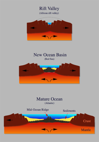
If the Earth's crust was expanding along the oceanic ridges, Hess reasoned, it must be shrinking elsewhere. He suggested that new oceanic crust continuously spread away from the ridges in a conveyor belt-like motion. Many millions of years later, the oceanic crust eventually descends into the oceanic trenches -- very deep, narrow canyons--that occur at convergent plate boundaries along the rim of the Pacific Ocean basin. According to Hess, the Atlantic Ocean was expanding while the Pacific Ocean was shrinking. As old oceanic crust was consumed in the trenches, new magma rose and erupted along the spreading ridges to form new crust. In effect, the ocean basins were perpetually being "recycled," with the creation of new crust and the destruction of old oceanic lithosphere occurring simultaneously.
The theory of seafloor spreading explains how new ocean crust is formed at ocean ridges and destroyed at deep ocean trenches (the next page shows an animation of what this looks like). Thus, Hess' ideas neatly explained why the Earth does not get bigger with sea floor spreading, why there is so little sediment accumulation on the ocean floor, and why oceanic rocks are much younger than continental rocks.
Source
http://pubs.usgs.gov/gip/dynamic/historical.html (public domain)
http://pubs.usgs.gov/gip/dynamic/developing.html (public domain)
4. READ: Evidence for Seafloor Spreading
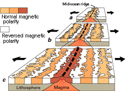
Another technological advance that aided the development of plate tectonics was the magnetometer, a device that measures small changes in magnetic fields. Scientists studying the seafloor with magnetometers began recognizing odd magnetic variations across the ocean floor. This finding, though unexpected, was not entirely surprising because it was known that basalt -- the iron-rich, volcanic rock making up the ocean floor-- contains a strongly magnetic mineral (magnetite) and can locally distort compass readings. More important, because the presence of magnetite gives the basalt measurable magnetic properties, these newly discovered magnetic variations provided another means to study the deep ocean floor.
Early in the 20th century, paleomagnetists (those who study the Earth's ancient magnetic field) recognized that rocks generally belong to two groups according to their magnetic properties. One group has so-called normal polarity, characterized by the magnetic minerals in the rock having the same polarity as that of the Earth's present-day magnetic field. This would result in the north end of the rock's "compass needle" pointing toward magnetic north. The other group, however, has reversed polarity, indicated by a polarity alignment opposite to that of the Earth's present magnetic field. In this case, the north end of the rock's compass needle would point south. How could this be? This answer lies in the magnetite in volcanic rock. Grains of magnetite -- behaving like little magnets -- can align themselves with the orientation of the Earth's magnetic field. When magma (molten rock containing minerals and gases) cools to form solid volcanic rock, the alignment of the magnetite grains is "locked in," recording the Earth's magnetic orientation or polarity (normal or reversed) at the time of cooling.
This is important to the theory of plate tectonics because it provided scientists with evidence of plate movement. When scientists studied the ocean floor with magnetometers, they discovered that the regions with normal and reverse polarity formed a series of stripes across the seafloor, parallel to the mid-ocean ridge. They also discovered that the ages and width of those stripes matched from one side of the ridge to the other. This symmetry showed scientists that new ocean crust was being created at mid-ocean ridges as two plates were forced apart at divergent plate boundaries.
Source: http://pubs.usgs.gov/gip/dynamic/developing.html (public domain)
5. VIEW: Theory of Plate Tectonics
Evidence for the theory of seafloor spreading came from many sources: (1) there is high heat flow out of the mid-ocean ridge; (2) the youngest oceanic rock was found in the ridge, and progressively older rock was found farther out from the ridge; (3) the youngest rocks at the ridge crest always have present-day (normal) polarity; (4) stripes of rock parallel to the ridge crest alternated in magnetic polarity (normal-reversed-normal, etc.), suggesting that the Earth's magnetic field has flip-flopped many times; and (5) mid-ocean ridges have very little sediment, while sediment thickness increases on either side of the ridge. The age, sediment thickness, and magnetic patterns are all nicely explained by seafloor spreading.
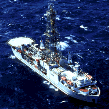
Additional evidence was gathered by the research vessel Glomar Challenger in the late 1960s. This ship drilled into the ocean floor to collect rock samples that were analyzed and dated, providing irrefutable evidence of seafloor spreading.
Once scientists realized that Hess was right, it did not take long for them to resurrect Wegener’s idea. If the seafloor were splitting apart, wouldn’t that cause the continents to move apart also? The reasoning went something along these lines: If the seafloor were spreading, then this action would provide the motion that would cause the continents to move.
The stage was set for the development of a new theory. The ideas of continental drift and seafloor spreading were combined into a new theory called plate tectonics.
Source: http://pubs.usgs.gov/gip/dynamic/historical.html (public domain)
