WATCH: Weather (BrainPop)
| Site: | Mountain Heights Academy OER |
| Course: | Earth Science Q3 |
| Book: | WATCH: Weather (BrainPop) |
| Printed by: | Guest user |
| Date: | Friday, 1 August 2025, 3:39 AM |
1. What is Weather? (BrainPop)

Floods can occur when atmospheric conditions allow a storm to remain in a given area for a length of time, or when a severe thunderstorm dumps very large amounts of rainfall in a short time period. When the ground becomes saturated with water, he excess runoff flows into low-lying areas or rivers and causes flooding.
A tornado begins in a severe thunderstorm. Vertical wind shear causes the updraft in the storm to rotate and form a funnel. The rotational wind speeds increase and vertical stretching occurs due to angular momentum. As air is drawn into the funnel core, it cools rapidly and condenses to form a visible funnel cloud. The funnel cloud descends to the surface as more air is drawn in. Wind speeds in tornadoes can reach several hundred miles per hour. Tornadoes are most prevelant in the Great Plains region of the United States, forming when cold dry polar air from Canada collides with warm moist tropical air from the Gulf of Mexico.

A cyclone is an area of low pressure with winds blowing counter-clockwise (Northern Hemisphere) or clockwise (Southern Hemisphere) around it. Tropical cyclones are given different names depending on their wind speed. The strongest tropical cyclones in the Atlantic Ocean (wind speed exceeds 74 miles per hour) are called hurricanes. These storms are called typhoons (Pacific Ocean) or cyclones (Indian Ocean) in other parts of the world. Hurricanes are the most powerful of all weather systems, characterized by strong winds and heavy rain over wide areas. They form over the warm tropical ocean and quickly lose intensity when they move over land. Hurricanes affecting the continental United States generally occur from June through November.

http://www.teachersdomain.org/resource/rr10.sci.earth.meteo.weath/ and Weather. NROC. Retrieved from http://www.curriki.org/xwiki/bin/view/Coll_NROCscience/Lesson22Weater?bc=&viewer=info on December 2, 2010.
2. Weather
3. Collecting Weather Data
To make a weather forecast, the conditions of the atmosphere must be known for that location and for the surrounding area. Temperature, air pressure, and other characteristics of the atmosphere must be measured and the data collected.
Thermometers measure temperature. In an old-style mercury thermometer, mercury is placed in a long, very narrow tube with a bulb. Because mercury is temperature sensitive, it expands when temperatures are high and contracts when they are low. A scale on the outside of the thermometer matches up with the air temperature.
Some modern thermometers use a coiled strip composed of two kinds of metal, each of which conducts heat differently. As the temperature rises and falls, the coil unfolds or curls up tighter. Other modern thermometers measure infrared radiation or electrical resistance. Modern thermometers usually produce digital data that can be fed directly into a computer.
Meteorologists use barometers to measure air pressure. A barometer may contain water, air, or mercury, but like thermometers, barometers are now mostly digital. A change in barometric pressure indicates that a change in weather is coming. If air pressure rises, a high pressure cell is on the way and clear skies can be expected. If pressure falls, a low pressure cell is coming and will likely bring storm clouds. Barometric pressure data over a larger area can be used to identify pressure systems, fronts, and other weather systems.
Weather stations contain some type of thermometer and barometer. Other instruments measure different characteristics of the atmosphere, such as wind speed, wind direction, humidity, and amount of precipitation. These instruments are placed in various locations so that they can check the atmospheric characteristics of that location. Weather stations are located on land, the surface of the sea, and in orbit all around the world.
Radiosondes measure atmospheric characteristics, such as temperature, pressure, and humidity as they move through the air. Radiosondes in flight can be tracked to obtain wind speed and direction. Radiosondes use a radio to communicate the data they collect to a computer. Radiosondes are launched from about 800 sites around the globe twice daily to provide a profile of the atmosphere. Radiosondes can be dropped from a balloon or airplane to make measurements as they fall. This is done to monitor storms, for example, since they are dangerous places for airplanes to fly.
Radar stands for Radio Detection and Ranging. A transmitter sends out radio waves that bounce off the nearest object and then return to a receiver. Weather radar can sense many characteristics of precipitation: its location, motion, intensity, and the likelihood of future precipitation. Doppler radar can also track how fast the precipitation falls. Radar can outline the structure of a storm and can be used to estimate its possible effects.
Weather satellites have been increasingly important sources of weather data since the first one was launched in 1952. Weather satellites are the best way to monitor large-scale systems, such as storms. Satellites are able to record long-term changes, such as the amount of ice cover over the Arctic Ocean in September each year.
Weather satellites may observe all energy from all wavelengths in the electromagnetic spectrum. Visible light images record storms, clouds, fires, and smog. Infrared images record clouds, water and land temperatures, and features of the ocean, such as ocean currents.
Source: Collecting Weather Data. Retrieved from http://www.ck12.org/book/CK-12-Earth-Science-Concepts-For-High-School/r16/section/9.29/ on August 26, 2013.
4. Tornadoes (BrainPop)

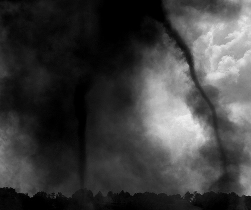
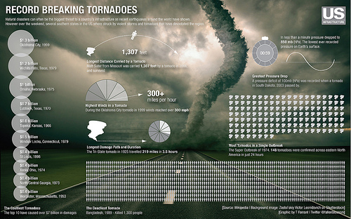
The damage tornadoes leave in their wake can be breathtaking and otherworldly: trees snapped like matchsticks, vehicles thrown hundreds of meters, and homes reduced to foundations. Scientists estimate that the most powerful of these terrifying storms produce winds topping 500 kilometers per hour. Meter for meter, they're considered the most violent of all weather events. Yet, surprisingly, they harness only a fraction of the energy contained in the storms that spawn them.

Tornadoes are powerful precisely because they concentrate huge amounts of energy into columns of air often just a couple of hundred meters in diameter. This intense concentration requires that a variety of weather variables and events occur in precise combination. Meteorologists are working hard to identify some of these variables in an effort to improve the predictability of one of Earth's most unpredictable phenomena.
The formation of the most intense tornadoes requires the most powerful of all thunderstorms, called supercells. These storms account for less than 10 percent of all thunderstorms. Tornadoes may occur anywhere in the world, except Antarctica, but tornadoes are most common in the middle latitudes. Tornadoes most often occur in North America, Australia, Europe, Africa, Asia, and South America. Two of the most common places outside the US are Bangladesh and Argentina. Three out of every four tornadoes typically form in the United States in the spring, between the Rocky and Appalachian Mountains. In this area, warm, moist air moving north from the Gulf of Mexico clashes with cooler, drier air, and the warm, less-dense air rises and cools. As it does, the moisture in the air begins to condense. This releases heat, which fuels the air's continued upward movement. Supercells differ from average thunderstorms in that they develop internal rotating features known as mesocyclones and are generally longer-lived. Changes in the wind speed and direction of a rising column of air together with the unstable air masses of the Great Plains cause supercell updrafts to be extremely powerful. With extreme instability in the environment and changing winds leading to rotating mesocyclones, supercell thunderstorms are ripe for producing tornadoes.
Still, only about 20 percent of the strongest supercells result in tornadoes. Scientists aren't certain why, since some of the factors that trigger the last steps of tornado formation aren't known, but they think they have some leads. One possibility is that powerful downward winds caused by heavy precipitation and differences in air pressure, called downdrafts, wrap around and concentrate winds rotating in the supercell. Computer models have brought to light another possibility: They show many tiny columns of spinning air, called vortices, very close to the ground just before a tornado develops. Scientists hypothesize that these vortices join together and, in so doing, form the tornado.
Tornado size and intensity is measured on the Enhanced Fujita scale. The E-F scale runs from EF-0 to EF-5 (with EF-5 causing the most damage and having the highest wind speed).
5. Hurricanes(brainPop)
Hurricanes originate over warm tropical oceans. The heat of the water provides the energy needed for the storm to develop and maintain itself. Water at temperatures below 26°C (80°F) does not have enough heat to produce a hurricane. This is why hurricanes in the northern hemisphere develop in the late summer or early autumn months, when Caribbean and Atlantic Ocean temperatures are at their warmest.
A hurricane begins when winds blowing across the surface of the warm ocean water converge to form clusters of strong thunderstorms known as tropical disturbances or tropical waves. The water fuels these thunderstorms, causing them to build. As they do, more water evaporates from the ocean surface and enters the air as water vapor. When the rising air cools, the water vapor condenses to form clouds, a process that releases heat. This heat warms the center, or eye, of the storm, which in turn causes more water to evaporate. Meteorologists call this chain reaction a "heat engine." The result is a reduction of air pressure at the water's surface and — if the winds, moisture, and ocean temperature continue to remain favorable — the formation of a hurricane.
Hurricanes are classified into 5 categories on the Saffir-Simpson scale, based on their size and intensity. Category 1 hurricanes are the smallest and category 5 hurricanes are the largest. Categories are based on wind speed and the potential for damage.
After you have completed this part of the lesson, you can check the associated box on the main course page to mark it as complete