READ: Seafloor Spreading

Bathymetric Evidence for Seafloor Spreading


Echo Sounders

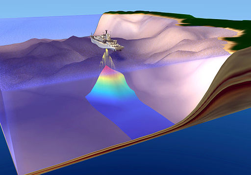
During World War II, battleships and submarines carried echo sounders. Their goal was to locate enemy submarines. Echo sounders produce sound waves that travel outward in all directions. The sound waves bounce off the nearest object and then return to the ship. Scientists know the speed of sound in seawater. They then can calculate the distance to the object that the sound wave hit. Most of these sound waves did not hit submarines. They instead were used to map the ocean floor. The study of the ocean floor is called bathymetry. Studying the ocean floor helped scientists to locate the mechanism for moving continents.

Seafloor Features

Scientists expected the seafloor to be flat and featureless. So they were shocked by what they saw: tremendous topographical features like mountain ranges, rifts, and trenches. Oceanographic research vessels continue to map the seafloor as they sail across the seas today. The map below is a modern map with data from several decades.

The major features of the ocean basins and their colors on the map include:

  • mid-ocean ridges: A long chain of mountains that rises up high above the deep seafloor. An example is the light blue gash in middle of Atlantic Ocean in the map below. Light blue is higher elevation than dark blue.
  • rift zones: In the middle of the mid-ocean ridges is a rift zone. The rift cuts the ridge into pieces. It is lower in elevation than the mountains of the mid-ocean ridge.
  • deep sea trenches: Trenches are found in the sea. Some are near the edges of continents. Trenches are found near chains of active volcanoes. An example is the line of the very deepest blue, off of western South America.
  • abyssal plains: Flat areas that may be dotted with volcanic mountains. An example is the consistent blue off of southeastern South America.
  • guyots: Flat topped mountains that appear to have been eroded. Yet these mountains are thousands of feet below sea level.
  • continental margin: The transition from the land to the deep sea. The continental margin is made of continental crust. More than one-quarter of the ocean basin is continental margin.

See if you can identify each of these features on the map below.

https://commons.wikimedia.org/wiki/Category:Bathymetric_maps#/media/File:Cape_Verde_Rise.jpg


Of course the first scientists to observe these features wondered how they had formed. It turns out that they were crucial for fitting together ideas about seafloor spreading. And seafloor spreading would turn out to be the mechanism for continental drift.

Seafloor Magnetism

Warships also carried magnetometers. Like the echo sounders, the magnetometers were used to search for submarines. The magnetometers also revealed a lot about the magnetic properties of the seafloor.

Polar Reversals

Looking at the magnetism of the seafloor, scientists discovered something astonishing. Many times in Earth’s history, the magnetic poles have switched positions. North becomes south, and south becomes north! When the north and south poles are aligned as they are now, geologists say it is normal polarity. When they are in the opposite position, they say that it is reversed polarity.

Magnetic Stripes

Scientists were even more surprised to discover a pattern of magnetism on the seafloor. There are stripes with different magnetism. Some stripes have normal polarity and some have reversed polarity. These stripes surround the mid-ocean ridges. There is one long stripe with normal magnetism at the top of the ridge. Next to that stripe are two long stripes with reversed magnetism. One is on either side of the normal stripe. Next come two normal stripes and then two reversed stripes, and so on across the ocean floor. The magnetic stripes end abruptly at the edges of continents. Sometimes the stripes end at a deep sea trench (figure below). Magnetometers are still towed behind research ships. They continue to map the magnetism of the seafloor.

Diagram of magnetic polarity changes in the seafloor

Seafloor Ages

Different seafloor magnetic stripes equal different ages. By using geologic dating techniques, scientists could figure out what these ages are. They found that the youngest rocks on the seafloor were at the mid-ocean ridges. The rocks get older with distance from the ridge crest. Scientists were surprised to find that the oldest seafloor is less than 180 million years old. This may seem old, but the oldest continental crust is around 4 billion years old.

Scientists discovered another way to tell the approximate age of seafloor rocks. The rocks at the mid-ocean ridge crest are nearly sediment free. The crust is also very thin there. With distance from the ridge crest, the sediments and crust get thicker. This also supports the idea that the youngest rocks are on the ridge axis, and that the rocks get older with distance away from the ridge (figure below). This is because the crust is new at the ridge, and so it is thin and has no sediment. The crust gets older away from the ridge crest. It has cooled and has more sediment.

Diagram of the age of the seafloor

Seafloor is youngest near the mid-ocean ridges and gets progressively older with distance from the ridge. Orange areas show the youngest seafloor. The oldest seafloor is near the edges of continents or deep sea trenches.

This leads to an important idea: some process is creating seafloor at the ridge crest. Somehow the older seafloor is being destroyed. Finally, we get to the mechanism for continental drift.

Seafloor Spreading Hypothesis

How do the continents move?

Harry Hess was a geology professor and a naval officer. He commanded an attack transport ship during WWII. Hess was intrigued by the seafloor maps produced with the ship's echo sounder. He thought about all of the evidence for continental drift. He thought about all of the unusual features of the seafloor. And he found the mechanism to explain them all.

The Evidence Comes Together

World War II allowed scientists to make some puzzling observations. The observations came from seafloor bathymetry and magnetism. These observations are:

  • The seafloor has a large mountain range running through it. Deep trenches are found far from the ridges. Guyots have eroded tops that are deep below sea level.
  • The magnetic polarity of the seafloor changes. The center of the ridge is of normal polarity. Stripes of normal and reverse polarity are found symmetrical on both sides of the ridge.
  • The youngest seafloor is at the ridge. The oldest is farthest from the ridge. The oldest seafloor is much younger than the oldest continent.

Scientists needed to explain these observations.

Mantle Convection

Not long after Wegener's death, scientists recognized that there is convection in the mantle. Deeper material is hotter and so it rises. Near the surface, it becomes cooler and denser so it sinks. This creates a convection cell in the mantle.

Seafloor Spreading

After the war, Harry Hess put together the ideas and evidence he needed. Hess resurrected Wegener's continental drift hypothesis. He reviewed the mantle convection idea. He thought about the bathymetric features and the patterns of magnetic polarity on the seafloor. In 1962, Hess published a new idea that he called seafloor spreading.

Hess wrote that hot magma rises up into the rift valley at the mid-ocean ridges. The lava cools to form new seafloor. Later more lava erupts at the ridge. The new lava pushes the seafloor horizontally away from the ridge axis (figure below). The seafloor moves!

Magnetite crystals in the lava point in the direction of the magnetic north pole. The different stripes of magnetic polarity reveal the different ages of the seafloor.

In some places, the oceanic crust comes up to a continent. The moving crust pushes that continent away from the ridge axis as well. If the moving oceanic crust reaches a deep sea trench, the crust sinks into the mantle. The creation and destruction of oceanic crust is the reason that continents move.

Diagram of magma at the mid-ocean ridge creates new seafloor

Magma at the mid-ocean ridge creates new seafloor.

  • As oceanic crust moves away from the ridge crest, it pushes a continent away from the ridge axis.
  • If the oceanic crust reaches a deep sea trench, it sinks into the trench.
  • The oldest crust is coldest and lies deepest in the ocean.

The flat topped guyots were once active volcanoes that were above sea level. They were eroded at their tops. As the seafloor moved away from the ridge, the crust sank deeper. The tops of the guyots went below sea level.

The Mechanism for Continental Drift

Seafloor spreading is the mechanism that Wegener was looking for! Convection currents within the mantle drive the continents. The continents are pushed by oceanic crust, like they are on a conveyor belt. Over millions of years the continents move around the planet’s surface. The spreading plate takes along any continent that rides on it.


Summary

  • Echo sounders were used to search for enemy submarines during World War II. The depths they recorded allowed scientists to piece together bathymetric maps of the seafloor. Multi-beam sounders work on research vessels today.
  • These maps revealed amazing features like mid-ocean ridges, deep-sea trenches, and abyssal plains.
  • The features of the seafloor helped scientists to discover the mechanism for continental drift.
  • Data from magnetometers dragged behind ships looking for enemy submarines in WWII discovered amazing magnetic patterns on the seafloor.
  • The magnetic pole reverses from time to time. The north pole becomes the south pole, and the south pole becomes the north pole.
  • Rocks of normal and reversed polarity are found in stripes symmetrically about the mid-ocean ridge axis.
  • The seafloor is youngest at the ridge crest and oldest far away from the ridge crest. The oldest seafloor rocks are about 180 million years, much younger than the oldest continental rocks.
  • Seafloor spreading is a mixture different ideas and data. Continental drift and mantle convection are supported by bathymetric and magnetic data from the seafloor.
  • Harry Hess called his idea “an essay in geopoetry." This could be because so many ideas fit together so well. It could also be because, at the time, he didn’t have all the seafloor data he needed for evidence.
  • Seafloor spreading is the mechanism for the drifting continents.

CC-BY-NC http://www.ck12.org/earth-science/Magnetic-Evidence-for-Seafloor-Spreading/lesson/Magnetic-Evidence-for-Seafloor-Spreading-MS-ES/
CC-BY-NC http://www.ck12.org/earth-science/Seafloor-Spreading-Hypothesis/lesson/Seafloor-Spreading-Hypothesis-MS-ES/
CC-BY-NC http://www.ck12.org/earth-science/Bathymetric-Evidence-for-Seafloor-Spreading/lesson/Bathymetric-Evidence-for-Seafloor-Spreading-MS-ES/

After you have completed this part of the lesson, you can check the associated box on the main course page to mark it as complete

Last modified: Tuesday, 28 February 2017, 2:59 PM